
ファイル:Egypt Sudan claims.svg

この SVG ファイルのこの PNG プレビューのサイズ: 400 × 600 ピクセル. その他の解像度: 160 × 240 ピクセル | 320 × 480 ピクセル | 512 × 768 ピクセル | 682 × 1,024 ピクセル | 1,365 × 2,048 ピクセル。
元のファイル (SVG ファイル、512 × 768 ピクセル、ファイルサイズ: 461キロバイト)
概要
| 解説 |
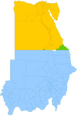
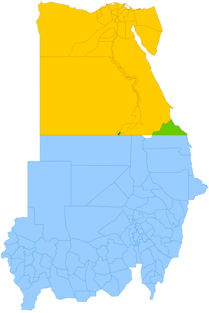
English: Simplified map showing Egypt's claim (yellow and green), Sudan's claim (blue and green), the Hala'ib Triangle (light green), Wadi Halfa Salient (dark green) and Bir Tawil (white). |
| 日付 | (UTC) |
| 原典 |
このファイルの派生元: |
| 作者 | |
| SVG 開発 |

ライセンス
このファイルはクリエイティブ・コモンズ 表示-継承 3.0 非移植ライセンスのもとに利用を許諾されています。
- あなたは以下の条件に従う場合に限り、自由に
- 共有 – 本作品を複製、頒布、展示、実演できます。
- 再構成 – 二次的著作物を作成できます。
- あなたの従うべき条件は以下の通りです。
- 表示 – あなたは適切なクレジットを表示し、ライセンスへのリンクを提供し、変更があったらその旨を示さなければなりません。これらは合理的であればどのような方法で行っても構いませんが、許諾者があなたやあなたの利用行為を支持していると示唆するような方法は除きます。
- 継承 – もしあなたがこの作品をリミックスしたり、改変したり、加工した場合には、あなたはあなたの貢献部分を元の作品とこれと同一または互換性があるライセンスの下に頒布しなければなりません。
元のアップロードログ
This image is a derivative work of the following images:
- File:Political_Regions_of_Sudan,_July_2010.svg licensed with Cc-zero
- File:Egypt_location_map.svg licensed with Cc-by-sa-3.0, GFDL
- 2011-04-17T16:03:10Z NordNordWest 1055x973 (359140 Bytes) upd
- 2010-03-07T17:03:18Z NordNordWest 1055x973 (566369 Bytes) resize
- 2009-09-03T10:48:31Z NordNordWest 1055x956 (565065 Bytes)
- 2009-05-23T19:10:12Z NordNordWest 1056x959 (570357 Bytes) corr
- 2008-08-10T11:12:09Z NordNordWest 1056x957 (503154 Bytes) {{Information |Description= {{de|Positionskarte von [[:de:Ägypten|Ägypten]]}} Quadratische Plattkarte, N-S-Streckung 110 %. Geographische Begrenzung der Karte: * N: 32.1° N * S: 21.3° N * W: 24.2° O * O: 37.3° O {{en|Lo
Uploaded with derivativeFX
ファイルの履歴
過去の版のファイルを表示するには、その版の日時をクリックしてください。
| 日付と時刻 | サムネイル | 寸法 | 利用者 | コメント | |
|---|---|---|---|---|---|
| 現在の版 | 2021年10月13日 (水) 11:15 | | 512 × 768 (461キロバイト) | Cmglee | Shade Wadi Halfa Salient as per http://commons.wikimedia.org/wiki/File_talk:Egypt_Sudan_claims.svg#Wadi_Halfa_Salient |
| 2019年2月16日 (土) 12:58 |  | 512 × 768 (461キロバイト) | AntiCompositeNumber | Avoid messing with file structure so much when <!-- --> will work | |
| 2019年2月16日 (土) 12:51 |  | 512 × 768 (465キロバイト) | AntiCompositeNumber | Remove striping that makes image harder to see per request at e n:Wikipedia:Graphics_Lab/Map_workshop | |
| 2018年6月21日 (木) 17:47 |  | 512 × 768 (461キロバイト) | Cmglee | Add white background as per File_talk:Egypt_Sudan_claims.svg#Bir_Tawil_area | |
| 2015年11月8日 (日) 17:44 |  | 512 × 768 (460キロバイト) | McGeddon | Remove unnecessary captions, image is colour-coded. | |
| 2013年1月11日 (金) 21:28 |  | 512 × 768 (461キロバイト) | Cmglee | Update colours and label alignment. | |
| 2013年1月11日 (金) 21:19 |  | 512 × 768 (461キロバイト) | Cmglee | == {{int:filedesc}} == {{Information |Description={{en|Map showing political regions of Sudan as of July 2006.}} {{legend|#8cc63f|Darfur}} {{legend|#fb6282|Nuba Mountains and Blue Nile}} {{legend|#f7931d|North Sudan}} {{legend|#800080|Eastern Front, ar... |
ファイルの使用状況
以下のページがこのファイルを使用しています:
グローバルなファイル使用状況
以下に挙げる他のウィキがこの画像を使っています:
- ar.wikipedia.org での使用状況
- arz.wikipedia.org での使用状況
- az.wikipedia.org での使用状況
- be.wikipedia.org での使用状況
- cs.wikipedia.org での使用状況
- da.wikipedia.org での使用状況
- de.wikipedia.org での使用状況
- de.wikivoyage.org での使用状況
- el.wikipedia.org での使用状況
- en.wikipedia.org での使用状況
- en.wikivoyage.org での使用状況
- eo.wikipedia.org での使用状況
- es.wikipedia.org での使用状況
- fi.wikipedia.org での使用状況
- fr.wikipedia.org での使用状況
- gl.wikipedia.org での使用状況
- id.wikipedia.org での使用状況
- it.wikipedia.org での使用状況
- ja.wikipedia.org での使用状況
- ko.wikipedia.org での使用状況
- ms.wikipedia.org での使用状況
- nl.wikipedia.org での使用状況
- no.wikipedia.org での使用状況
- pt.wikipedia.org での使用状況
- ro.wikipedia.org での使用状況
- so.wikipedia.org での使用状況
- sr.wikipedia.org での使用状況
- uk.wikipedia.org での使用状況
- vi.wikipedia.org での使用状況
- www.wikidata.org での使用状況
- zh.wikipedia.org での使用状況